-
Notifications
You must be signed in to change notification settings - Fork 1
Main application page description (Swing SDI)
JAtcSim supports multiple user interface layouts, as it has an extendable model. However, now only two are implemented, SDI and MDI models. Here SDI model is described.
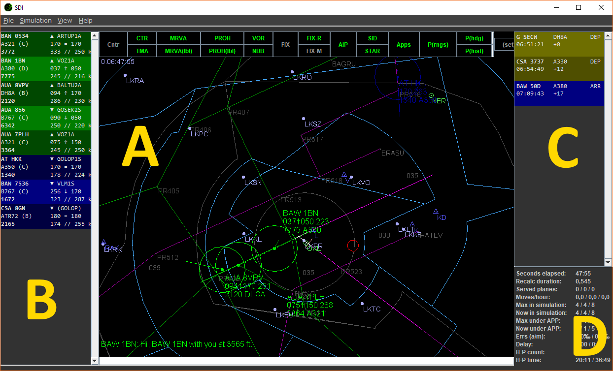
The main page in SDI layout looks like this:

The screen is divided into four sections:
- A - the main section of the radar screen
- B - the current flight strips
- C - the scheduled flights
- D - some statistics (in development)
On the top of the screen, there are buttons to adjust visible items in the radar. In the middle, the radar situation is presented. The airplanes are captured in different colors depending on their state and responsible ATC. On the bottom, there is a very important command line where a user can enter commands for airplanes. This is the main tool used to drive the aircraft.
The aircraft information again depends on the aircraft state and responsible air traffic controller. For approach, visible information is: callsign, altitude, altitude derivation, target altitude, squawk and airplane type, like:
EZY 5495
056↑080 247
1203 A319
That means EZY 5495 is climbing (arrow ↑) through FL56 to FL80, the current indicated sped is 247kts, squawk (used when hanging off to another controller) is 1203 and airplane type is Airbus A319.
There are also messages visible on the main radar screen. There are four types of messages:
- time - in the top left corner
- messages from airplanes - in the bottom left corner
- messages from other atcs - in the bottom right corner
- system messages - in the top right corner

(Note that the current radar color scheme should be different from the displayed one.)
There are several things visible on the radar panel:
- Airplanes - airplanes are displayed as a dot with an optional heading line and optional history dots. The airplane also has its label containing information about the plane as explained above.
- Navigation aids - VOR, NDB, and FIX navigation points (also mentioned as navaids). They differ by their color and shape:
- VOR is a green circle with a dot inside,
- NDB is a dark blue triangle with a dot inside,
- FIX is a simple gray dot. Their color differs as they are "normal", route (on some sid/star/transition) or minor.
- Other airports - other airports are displayed as thick dots,
- SID - departure routes - as green lines, from the active departing runway(s),
- STAR/transitions - arrival routes - as purple lines, to the active arrival runway(s),
- major airport active runways - as white lines,
- major airport closed runways - as gray lines,
- TMA or CTR borders - defining airport range, as blue/cyan enclosed polygons,
- MRVA areas - areas with minimal vectoring altitudes, as gray enclosed polygons,
- restricted areas - areas where flying is restricted, as red enclosed polygons.
The visibility of many aforementioned elements can be adjusted in the radar top panel.

The panel at the top of the radar screen is used to control the displayed items in the label. The available items are:
- Cntr - show/hide country borders
- CTR - show/hide CTR
- TMA - show/hide TMA(s)
- MRVA - show/hide MRVA
- MRVA(lbl) - show/hide MRVA minimal altitudes
- PROH - show/hide prohibited and restricted areas
- PROH(lbl) - show/hide prohibited and restricted areas altitude ranges
- VOR - show/hide VORs
- NDB - show/hide NDBs
- FIX - show/hide all FIXes
- FIX-R - show/hide FIXes on the active SIDs/STARs/transitions
- FIX-M - show/hide minor (not important) FIXes
- AIP - show/hide other local airports
- SID - show/hide SIDs; by the right mouse click, custom SIDs can be selected
- STAR - show/hide STARs/transitions; by the right mouse click, custom STARs/transitions can be selected
- Apps - show/hide approach lines for active runway(s); by the right mouse click, custom approaches can be selected
- P(rngs) - show/hide airplane distance rings
- P(hdg) - show/hide an airplane heading line
- P(hist) - show/hide airplane history dots
New element can be added during the development.

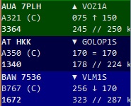
In this panel, there is information about all active flights in the area. The background color indicates responsible atc.
The displayed information are:
{Callsign}  {arr/dep} {route}
{Airplane type and category} {current}{up/down}{target altitude}
{squawk} {heading}//{indicated speed}
For example, in the aforementioned image:
AUA 08QJ   ▲ VOZ1A
A319 (C)   069↑170
0357       245 // 250 kts
... means that flight AUA 08QJ is a departure (▲ symbol) via VOZ1A route. It is Airbus A319 airplane of category (C), currently passing FL69 climbing(↑) to FL170. The squawk of the flight is 0357, current heading is 245°, current IAS speed is 250kts.

Scheduled flighs panel is on the right. It shows following information:
{callsign} {airplane-type} {arrival/departure}
{on-screen-time} {delay-in-minutes}
Statistics panel is on the bottom right side of the screen. It is under development, so the following layout information may be out of date. However, the displayed information is:
- Seconds elapsed in the game
- How log takes it to recalculate the simulation. This value should be < 1, as the simulation is evaluated every second. It is only for testing purposes to see how complex the background computation is and if the optimization is needed :-)
- Number of served planes - departures/arrivals/total
- Movements per hour - departures/arrivals/total. Value is increased when airplane stopped on the runway (arrivals) or is no more served by the center atc (departures).
- Max planes in game - departures/arrivals/total
- Current number of planes in game - departures/arrivals/total
- Max planes in control under player (that is approach atc) - departures/arrivals/total
- Current number of planes in control under player - departures/arrivals/total
- Number of planes at the holding point (ready for departure) - current/maximum
- Time how long the planes are waiting on the holding point - mean/maximum
-
Commands
-
Other
- Fleet
- Traffic
- Area
- Startup settings